Satellite based locust habitat monitoring in the Aral Sea basin

Satellite based locust habitat monitoring in the Aral Sea basin

April 16, 2015

Aralsea_Fabian_Loew

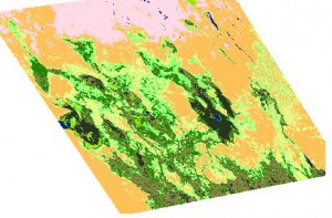
Land cover map 2014

The Central Asia research team at the Department of Remote Sensing, Würzburg University, recently started investigating potential risk areas for infestation of the Asian Migratory locust, Locusta migratoria migratoria L., in the Aral Sea basin.

Asian Migratory locust is a serious crop pest in the Amudarya River delta near the Aral Sea in Uzbekistan, Central Asia. Its economic importance increased after desiccation of the Aral Sea. Vast areas of the former sea bottom became covered with stands of common reeds Phragmites australis, which are well-known as the main breeding locust habitat in this region.  In order to enable efficient locust monitoring, accurate information about the spatial distribution of reeds is essential.

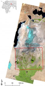
Aralsea_studyarea_Fabian_Loew

Study area in the lower Amudarya delta

Traditional ground-based locust monitoring is hardly possible in most areas of the delta, particularly on the former sea bottom. Due to its high revisit frequency, adequate spectral resolution and synoptic coverage, data from the MODIS satellite sensor aboard the Terra and Aqua platforms can provide the required information about spatio-temporal reed distribution in the Amudarya delta.

Additional efforts are recently spent on extending the methodology to provide early detection of potential breeding habitats within the growing season, and to analyze the correlation of water inflow to the delta and the spatial extent of locust breeding habitats. The results are instrumental for predicting potential locust outbreaks and developing better targeted management plans.

First results of our research will be presented at the upcoming IGU conference in Moscow.

For more information regarding recent and future research activities in this field, or interest in B.Sc. or M.Sc. thesis, contact Dr. Fabian Löw from the Department of Remote Sensing in Würzburg.

you may also like:

PhD position: Earth Observation of drought and fire impacts

PhD position: Earth Observation of drought and fire impacts

Job Announcement: PhD Position on EO research of Drought, Fire and Vegetation in Kruger National Park, South Africa Position: PhD ResearcherStudy Area: Kruger National Park, South AfricaApplication Deadline: until position is filledStart Date: as soon as possible...

EO4Cam meeting at LfU in Augburg

EO4Cam meeting at LfU in Augburg

As part of the EO4Cam project (Earth Observation Laboratory for Climate Adaption and Mitigation https://www.dlr.de/de/site/eo4cam/ ), representatives of the State Ministry for the Environment and Consumer Protection (StMUV), the State Office for the Environment (LFU)...

Guests from Koforidua Technical University

Guests from Koforidua Technical University

Two lecturers from our ERASMUS+ KA171 partner institution Koforidua Technical University in Würzburg are currently visiting us. The aim of Linda Appiah Boamah and Clement Nyamekye's visit is to further strengthen our cooperation on student exchange within the project....

Successful Master Thesis Defense by Svenja Dobelmann

Successful Master Thesis Defense by Svenja Dobelmann

On January 21st, Svenja Dobelmann successfully defended her master's thesis titled "Linking Wildlife Conservation to Nature’s Contributions to People: A Case Study for the European Wildcat (Felis silvestris silvestris) in German Protected Forests" supervised by Dr....

Empowering Future Earth Observation Experts! 🌍

Empowering Future Earth Observation Experts! 🌍

At EAGLE, our Earth Observation students are diving deep into the fascinating world of geospatial analysis! Through hands-on training, they master cutting-edge algorithms and techniques to address pressing environmental challenges such as Georisk Assessment:...

AgriSens is working towards its final symposium

AgriSens is working towards its final symposium

Results from five years of research will be presented at the final symposium of the AgriSens DEMMIN 4.0 project. Its focus is the use of digitalisation and remote sensing technologies in agricultural practice, aiming for an agriculture that is ecological, economical...