new publication: Measuring rural settlement expansion in Uzbekistan using remote sensing to support spatial planning

new publication: Measuring rural settlement expansion in Uzbekistan using remote sensing to support spatial planning

April 29, 2015

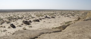
Aral Sea / ship graveyard in Muinak, Uzbekistan

Photo by C. Conrad

In this publication we focused on methods to measure the outcome of population growth in rural Uzbekistan. Bi-temporal change detection based on 2.5m SPOT data gave insights into the competition for valuable land resources.


Conrad, C., Rudloff, M., Abdullaev, I., Thiel, M., Löw, F., Lamers, J.P.A., Measuring rural settlement expansion in Uzbekistan using remote sensing to support spatial planning, Applied Geography, Volume 62, August 2015, Pages 29–43. http://www.sciencedirect.com/science/article/pii/S0143622815000831

you may also like:

MainPro Project Meeting: Next Project Phase Launched

MainPro Project Meeting: Next Project Phase Launched

On Friday, November 21st, a MainPro project meeting was held to exchange ideas with our cooperating small and medium-sized enterprises (SMEs). Within our MainPro project, we aim to identify the changes caused by climate change in the Main Valley and its surroundings...

Our EAGLE Coffee Meeting

Our EAGLE Coffee Meeting

At the beginning of each semester, we hold a series of small and informal EAGLE coffee meetings—a moment for new (and old) students to meet with our EAGLE admin and EORC staff members (also former international EAGLEs) in a relaxed atmosphere and ease into the rhythm...

EORC Staff Complete Joint First Aid Training

EORC Staff Complete Joint First Aid Training

Today, staff from the EORC successfully completed a joint first aid course held in our department. During the training, participants learned the essential methods needed to assist colleagues and students in case of injuries. The course covered practical techniques,...