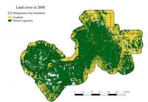
 Our former M.Sc. student Henrike published her work “Protection status and national socio-economic context shape land conversion in and around a key transboundary protected area complex in West Africa” where she outlined the capabilities of remotely sensed land cover information and its change over time to inform conservation activities. From the abstract: “ransboundary cooperation is being promoted as an effective way to conserve biodiversity that straddles national borders. However, monitoring the ecological outcomes of these large-scale endeavours is challenging, and as a result, the factors and processes likely to shape their effectiveness remain poorly identified and understood. To address this knowledge gap, we tested three hypotheses pertaining to natural vegetation loss across the W-Arly-Pendjari protected area complex, a key biodiversity hotspot in West Africa. Using a new methodology to compare land cover change across large remote areas where independent validation data is unevenly distributed across time, we demonstrate widespread agricultural expansion outside protected areas over the past 13 years.”
read more here: