New publication: Estimating over- and understorey canopy density by LiDAR data

New publication: Estimating over- and understorey canopy density by LiDAR data

August 27, 2015

A new publication recently appeared by Forestry opens some new outlook in leveraging airborne LiDAR derivatives for monitoring the vertical structure of temperate mixed forest stands. Led by Dr. Hooman Latifi from University of Würzburg, the study focuses on associating aerially-mapped habitat characteristics with 3D metrics extracted from fullwave LiDAR data to model canopy density across multiple stand stories.Whereas the
majority of methods applied so far typically concentrate on the structure of the overstorey, the main focus here is on the understorey layers of stands, which are of particular importance for wildlife and forest management applications, especially in protected areas.

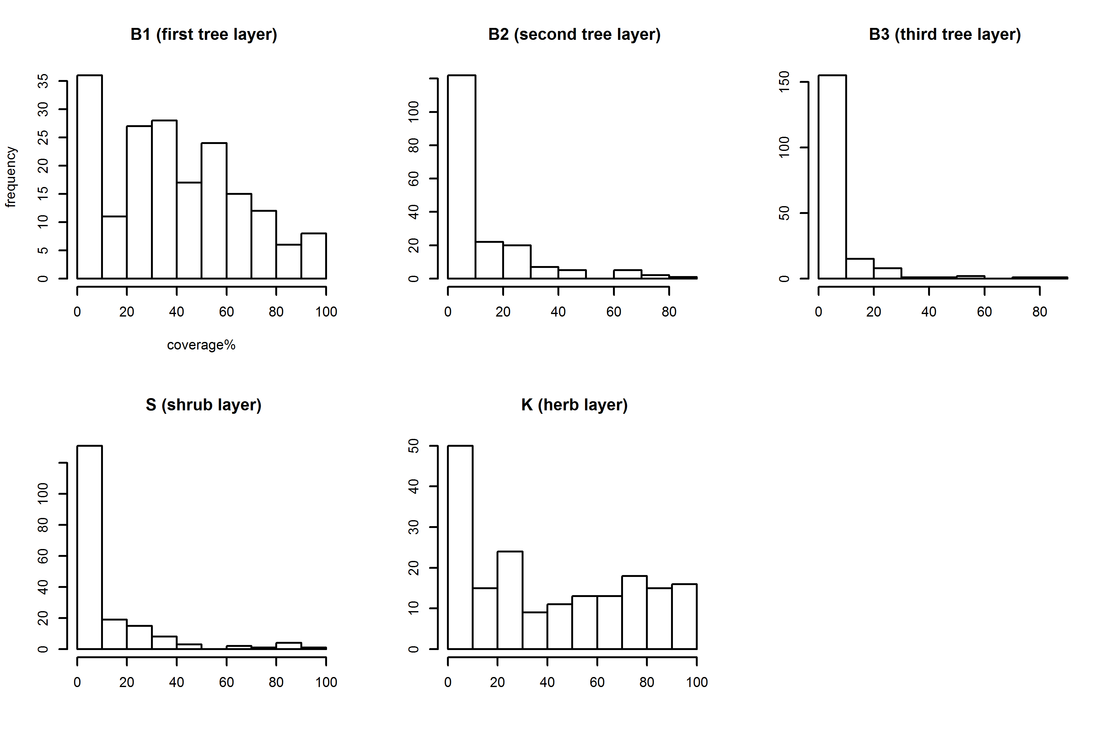
LiDAR metrics and information on forest habitat types were combined via regression models to investigate LiDAR metrics that are significantly correlated with vegetation density. The top canopy and the herbal layer showed strong correlations with the applied LiDAR metrics. Moreover, the results suggest that the relationship between LiDAR predictors and vegetation density depends on the forest type. In conclusion, this study highlights the value of the LiDAR metrics for characterizing the structural properties of lower forest layers, with direct and indorect implications for wildlife and forest management.

The published version of this article can be retrieved through the following link.

Latifi, H., Heurich, M., Hartig, F., Müller, J., Krzystek, P., Jehl, H., Dech, S. 2015. Estimating over- and understorey canopy density of temperate mixed stands by airborne LiDAR data. Forestry, DOI.10.1093/forestry/cpv032

you may also like:

Our research introduced to the JMU president Pauli

Our research introduced to the JMU president Pauli

At the Center for Artificial Intelligence and Data Science (CAIDAS) opening last Friday on 18th of April 2024, we had the opportunity to present the research of our Earth Observation Research Cluster (EORC) and of the Earth Observation Center (EOC) of the German...

UAS mission of monastery Bronnbach

UAS mission of monastery Bronnbach

The potential of UAS data for mapping cultural heritage sites was discussed in the past months with colleagues associated with the UNESCO world heritage activities by our postdocs Dr. Mirjana Bevanda and Dr. Sarah Schönbrodt-Stitt. Based on these discussions further...

Internship Report on Tuesday, April 30 at 14:00

Internship Report on Tuesday, April 30 at 14:00

On Tuesday, April 30 Konstantin Müller will present his internship " GDELT News Analysis of the Noto Earthquake via ERNIE" at 14:00 in 01.B.03, John-Skilton-Str. 4a. : From the abstract: The analysis of socioeconomic data has gained increasing importance. The exchange...

Internship Report on Tuesday, April 23 at 12:00

Internship Report on Tuesday, April 23 at 12:00

On Tuesday, April 23rd Elly Schmid will present her internship at 12:00 in seminar room 3, John-Skilton-Str. 4a. : From the abstract: The internship was carried out as part of the HEATS-(Urban heat) Project of the Georisks team at the Earth Observation Center, which...

New building for the CAIDAS AI center opened

New building for the CAIDAS AI center opened

CAIDAS, the Center for Artificial Intelligence and Data Science ( https://www.caidas.uni-wuerzburg.de/ ), was officially opened on April 19, 2024 with prominent guests from politics and science.  Bavaria's Minister of Science Markus Blume cut the ribbon for the new...