New Publication: Canopy structure-corrected retrieval of foliar nitrogen by hyperspectral data

New Publication: Canopy structure-corrected retrieval of foliar nitrogen by hyperspectral data

September 22, 2016

A new review paper has been recently published by International Journal of Applied Earth Observation and Geoinformation. The paper is amongst the outputs of a PhD thesis by Zhihui Wang from the University of Twente, and focuses on retrieval of forest canopy foliar nitrogen from hyperspectral imagery by additionally correcting for canopy structure effects. Te main research question arose from the fact that the interaction between leaf properties and canopy structure confounds the estimation of foliar nitrogen, which can be corrected for by using the canopy scattering coefficient (the ratio of BRF and the directional area scattering factor, DASF).
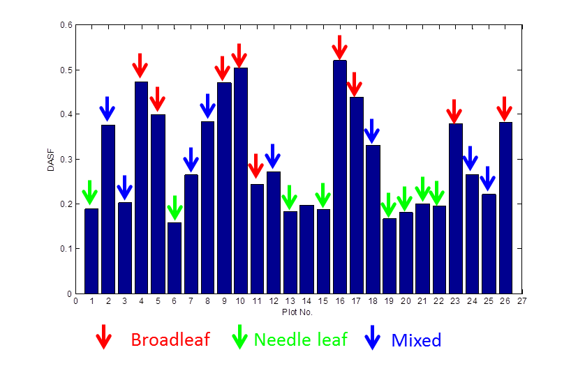
 

Directional area scattering factor (DASF) calculated based on spectral invariant theory for broadleaf, needle leaf, and mixed forest

The results of the research conducted across the Bavarian Forest National Park confirm that %N can be retrieved using the scattering coefficient aftercorrecting for canopy structural effect. With the aid of  upcoming space-borne hyperspectral imagery, large-scale foliar nitrogen maps can be generated to improve the modeling ofecosystem processes as well as ecosystem-climate feedbacks.

Further information on this paper can be found here.

Source:

Wang, Z., Skidmore, A. K., Wang, T., Darvishzadeh, R., Heiden, U., Heurich, M., Latifi, H., Hearne, J. 2016. Canopy foliar nitrogen retrieved from airborne hyperspectral imagery by correcting for canopy structure effects. International Journal of Applied Earth Observation and Geoinformation 54(2017): 84-94.

 

follow us and share it on:

you may also like:

New Technical publication on Regional Planning Smart Solution

New Technical publication on Regional Planning Smart Solution

Urban and regional planning increasingly relies on geospatial technologies to support evidence-based decision-making. Within the European research project FUTURAL – Empowering the Future of Rural Regions, researchers at the Earth Observation Center (EOC) of the...

How We Learned to Fly: The Story Behind UAS Research at EORC

How We Learned to Fly: The Story Behind UAS Research at EORC

Every research group that's ever bought a drone has a story about the first one it lost. We're no different. So let's just get that out of the way up front: this is the inside story of how UAS (Unoccupied Aerial System) research grew up at the Earth Observation...

Ticks from Above: UAS Fieldwork for the MONID Habitrack Project

Ticks from Above: UAS Fieldwork for the MONID Habitrack Project

Forest edges are tricky places. They're where woodland meets open ground, where light and shade trade off every few meters, and where, it turns out, ticks tend to do really well. That last bit is exactly why Dr. Ariane Droin, Sofía García de León, Dr. Jakob...

New paper on GDP estimatation from space

New paper on GDP estimatation from space

Reliable and up-to-date sub-national data on the gross domestic product (GDP) data remain scarce in many regions across the globe. However, in a new study we show how high-resolution GDP estimates can be derived from multisource remote sensing and auxiliary inputs...

Share This