New Paper: Stratified aboveground forest biomass estimation by remote sensing data

New Paper: Stratified aboveground forest biomass estimation by remote sensing data

February 20, 2015

A new paper published recently by Int. J. Appl. Earth Obs. Geoinf. presents the results of a systhematic survey on the effects of post-stratification of sampling units on the quality of remote sensing-assisted biomass models. This is somwhat controversial to the status quo in the literature, which mostly suggests that estimates can be improved by building species- or strata-specific biomass models.


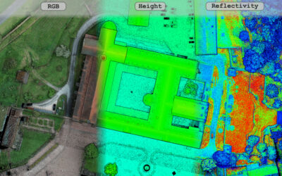
We analyzed the impact of stratifying forest data into three classes (broadleaved, coniferous and mixed forest). We compared predictive accuracy a) between the strata b) to a case without stratification for a set of pre-selected predictors from airborne LiDAR and hyperspectral data. The achieved RMSE and r2 diagnostic values were analyzed in a factorial design to rank the relative importance of each factor. Selected models were used for wall-to-wall mapping of biomass estimates and their associated uncertainty. The results revealed marginal advantages for the strata-specific prediction models over the unstratified ones, which were more obvious on the wall-to-wall mapped area-based predictions. Yet, further tests are necessary to establish the generality of these results. Input data type and statistical prediction method are concluded to remain the two most crucial factors for the quality of remote sensing-assisted biomass models.

A full text of this paper can be found at:

http://www.sciencedirect.com/science/article/pii/S0303243415000264


you may also like:

our research covered by television

our research covered by television

At the opening of the CAIDAS we also had the opportunity to present our research and development work to various media representatives. For example, we reported on our remote sensing work to ARD and Bayerischer Rundfunk as well as for Mainfranken TV - see e.g. here...

Our research introduced to the JMU president Pauli

Our research introduced to the JMU president Pauli

At the Center for Artificial Intelligence and Data Science (CAIDAS) opening last Friday on 18th of April 2024, we had the opportunity to present the research of our Earth Observation Research Cluster (EORC) and of the Earth Observation Center (EOC) of the German...

UAS mission of monastery Bronnbach

UAS mission of monastery Bronnbach

The potential of UAS data for mapping cultural heritage sites was discussed in the past months with colleagues associated with the UNESCO world heritage activities by our postdocs Dr. Mirjana Bevanda and Dr. Sarah Schönbrodt-Stitt. Based on these discussions further...

Internship Report on Tuesday, April 30 at 14:00

Internship Report on Tuesday, April 30 at 14:00

On Tuesday, April 30 Konstantin Müller will present his internship " GDELT News Analysis of the Noto Earthquake via ERNIE" at 14:00 in 01.B.03, John-Skilton-Str. 4a. : From the abstract: The analysis of socioeconomic data has gained increasing importance. The exchange...

Internship Report on Tuesday, April 23 at 12:00

Internship Report on Tuesday, April 23 at 12:00

On Tuesday, April 23rd Elly Schmid will present her internship at 12:00 in seminar room 3, John-Skilton-Str. 4a. : From the abstract: The internship was carried out as part of the HEATS-(Urban heat) Project of the Georisks team at the Earth Observation Center, which...

New building for the CAIDAS AI center opened

New building for the CAIDAS AI center opened

CAIDAS, the Center for Artificial Intelligence and Data Science ( https://www.caidas.uni-wuerzburg.de/ ), was officially opened on April 19, 2024 with prominent guests from politics and science.  Bavaria's Minister of Science Markus Blume cut the ribbon for the new...