

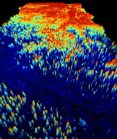
 A new MSc. student started her thesis “Suitability of Light detection and ranging (LiDAR) data and texture measures of aerial images to model the species distribution of Glaucidium passerinum (Pygmy Owl) in Vercors, French Alps”. Wanda Graf is using LiDAR data to describe the three dimensional habitat structure of Glaucidium passerinum at different scales. Moreover texture measures of aerial images will be used to describe the habitat structure of Glaucidium passerinum at different scales. It is assumed that LiDAR data are more suitable to model the distribution of Glaucidium passerinum than texture measures of aerial images. The thesis is supervised by Dr. Björn Reineking and Dr. Martin Wegmann

Mapping Lava Tubes on Mauritius with iPhone Pro LiDAR
Lava tube structures on Mauritius are quite hard to survey - tight, dark, and largely inaccessible to classical scanning equipment. As part of ongoing research by Dr. Kim Lea Holzmann (Chair of Animal Ecology and Tropical Biology, University of Würzburg), we're...


