MSc thesis handed in on predicting forest understory canopy cover

MSc thesis handed in on predicting forest understory canopy cover

May 9, 2016

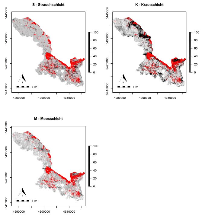
A M.Sc thesis was written by Bastian Schumann under the supervision of Dr. Hooman Latifi and Prof. Christopher Conrad that focused on a LiDAR-based approach to combine structural metrics and forest habitat informaiton for causal and predictive models of understory canopy cover. The data base used consisted of a bi-temporal LiDAR dataset as well as two field datasets and two habitat maps. The entire data were initially edited, revealing that a bi-temporal treatment is only possible for understory layers. The statistical models used for modelling canopy cover density included random forest, logistic models and zero-and-one inflated beta regression.

The results revealed the most relevant LiDAR metrics which contribute to explain the canopy cover density. Furthermore it indicates that the habitat types have a significant influence on canopy cover density. In addition, it was shown that with the use of a denser point cloud a higher performance can be achieved in almost every vertical stand layer.

Wall-to-wall predictions of understory canopy cover usign high density point cloud, habitat types and a logistic model

Wall-to-wall predictions of understory canopy cover usign high density point cloud, habitat types and a logistic model

you may also like:

Guided tour of the Märkisches Viertel in Berlin

Guided tour of the Märkisches Viertel in Berlin

Guided tour of the Märkisches Viertel in Berlin   As part of our research work on large housing estates, we had the opportunity to take part in a guided tour through the Märkisches Viertel in Berlin on 17.04.2024. The Märkisches Viertel has around 17,000...

preparation of official CAIDAS opening

preparation of official CAIDAS opening

On Friday the CAIDAS center will be officially opened and we are part of this great AI initiative at the University of Würzburg. For this event all members prepare specific showcases and info walls - we decided to show our Earth Observation research using interactive...